Mile (0) post at Dawson Creek marks the spot where our Alaska highway journey began through the northern part of the Rockies but first we took the time to look around this quaint town. Murals line the streets depicting it’s history, a visit to the information centre and a stop in at Alaska Highway house for its display and viewing of an hour long movie that relates the incredible story of the building of the highway. The need for the road through to Alaska came about when US became concerned about its security after the attack on Pearl Harbour. It took US troops a little over 8 months to put this road through untouched wilderness and to complete its 1528 miles, 133 major bridges and more than 3000 culverts all at a cost of $140 million US wartime dollars. After having pasties from the German bakery we left town taking the detour on the Old Alaskan highway so we could cross the only original timber bridge (mile 21) that is still in use. Each of the historical sites or points of interest are marked with milestone posts. It was then to Fort St John which is one location where the Army based themselves for construction of the highway and the second is Fort Nelson (300 mile) and today both towns are thriving around oil, gas and the forestry industry.
It is not hard to imagine how difficult a task it would have been to put this highway (not that it should be called a highway) although it is mostly bitumen the surface is very rough, winding through mountains where White Spruce and Lodge pole pines line the roads as far as the eye can see and rivers and streams flow through the valley’s. The road certainly bringing out the rattles and squeaks in the RV.
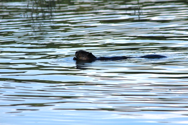
After stopping for lunch at Toad River (422 mile) Troopy had a problem with the starter motor solenoid and later down the track received a stone chip in the windscreen and our RV emission light came on which was caused by a hole in the muffler. Both vehicles still driveable we motored on. Wildlife has been plentiful seeing bison, stone sheep, black bears, squirrels and even some beavers in the Hyland River which was alongside our overnight campsite. One of our experiences with a black bear was amazing, crossing from the opposite side of the road he walked straight up to the window of the RV and sat down before moving around the other side of the RV doing the same looking at us like he was saying PLEASE feed me. Our cameras out the window , clicking away but the finger stayed on the button just in case it was a quick retrieve inside and windows up.
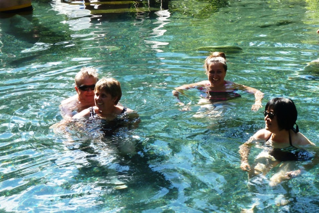
A stop off at Liard Hot springs and a swim was a welcomed break before continuing on to find an overnight camp site.
An early morning start to Watson Lake “Gateway to the Yukon” (635mile) to visit the famous landmark “signpost forest”. Until the end of 2010 70,000 visitors have added street signs, number plates, or home town souvenirs to the erected posts. Geoff and Kienny were another as they added a Northern Territory number plate signatured with their name and travel website details. We only left behind our footprints. From here we leave British Columbia behind (well almost) as we weaved in and out of it 7 times before remaining in Yukon Territory. It was then across the Nisutlin Bay Bridge which has the longest water span on the highway to Teslin (804 mile), which has the largest native population in the Yukon, a community whose lively hood revolves around traditional hunting, fishing and trapping.
Excitedly it was on to “Whitehorse” (918 mile) situated on the Yukon river where we were on time to pick up our travelling buddy Mal (Wendy’s husband) who flew in from Australia to join us for a few weeks. Whitehorse reminds us of Outback Australia, very similar to Alice Springs. Here we spent a couple of days attending to the repairs, washing and tidying vehicles and getting ready for the next part of the journey which will have us venturing away from the Alaska Highway for a bit.....
 |
| Alaska Hotel Dawson Creek |
 |
| Baby Mule deer waling in front of us |
 |
| Bear that came up alongside RV |
 |
| Beaver |
 |
| Alaska Highway |
 |
| Stone Sheep |
 |
| Stone sheep |
 |
| Bison |
 |
| Bridge surface suitable for ice |
 |
| Canada's Camping Rules |
 |
| Check out the door handles on RV Parks reception |
 |
| Alaskan Highway Dawson Creek |
 |
| As far as the eye can see |
 |
| Enjoying a swim at Liard Hot Springs |
 |
| Liard Hot Springs |
 |
| Muncho Lake sea plane |
 |
| Mural at Dawson Creek |
 |
| Mural at Dawson Creek |
 |
| O milepost at Dawson Creek |
 |
| Original Timber bridge at Milepost 21 |
 |
| Peace River |
 |
| Driving alongside river |
 |
| Saloon at RV park |
 |
| Troopy repairs |
 |
| Driving across the Historic Bridge |
 |
| wildflowers |
 |
| Tresspassers |
 |
| squirrell |
 |
| Alaska Information booth in an old RV |
 |
| 55 paces to 0 mile |
 |
| Geoff and Kienny with number plate |
 |
| Nisultin Bridge Longest Span on Alaska Highway |
 |
| Geoff putting up number plate |
 |
| signpost forest |
 |
| Teslin Heritage Centre totem poles |
 |
| We made it to the Continental divide |
 |
| Mal arrives in Whitehorse |
 |
| Dinner at Ribs and Salmon Whitehorse |


No comments:
Post a Comment